Σύμφωνα με το βρετανικό δημοσίευμα, η Χεζμπολάχ πιστεύεται ότι απογείωσε ένα drone προς αμερικανικά κατασκοπευτικά αεροσκάφη στη στρατιωτική βάση της RAF στο Ακρωτήρι της Κύπρου, νωρίτερα αυτόν τον μήνα, τα οποία ήταν ορατά σε δημόσια διαθέσιμες δορυφορικές εικόνες.
Εκτεθειμένη η βάση στο Ακρωτήρι
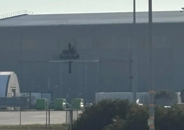
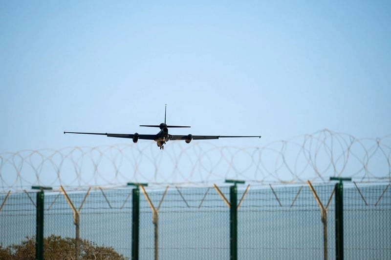
Δημόσια διαθέσιμες δορυφορικές εικόνες δείχνουν δύο αμερικανικά κατασκοπευτικά αεροσκάφη U2 σταθμευμένα ακριβώς έξω από το υπόστεγο που χτυπήθηκε στην επίθεση.
Μια στρατιωτική πηγή δήλωσε ότι η επίθεση ήταν ανησυχητική «επειδή χτυπούσαν αυτό που στόχευαν», αλλά πρόσθεσε πως ήταν απίθανο να ήταν αποτέλεσμα μιας εξελιγμένης επιχείρησης συλλογής πληροφοριών.
Μάλλον, «αυτό υποδηλώνει ότι έχουν Google Maps και GPS», δήλωσε η πηγή.
Κατόπιν αιτήματος των κυβερνήσεων, η Google μπορεί να θολώσει, να αποκρύψει ή να αφαιρέσει λεπτομέρειες ευαίσθητων τοποθεσιών, ώστε να μην είναι ορατές στο κοινό.
Ορισμένες ισραηλινές και αμερικανικές αεροπορικές βάσεις στην περιοχή εμφανίζονται στον ιστότοπο, αλλά σε χαμηλότερη ανάλυση ή με τα αεροσκάφη να είναι εντελώς θολά, για λόγους ασφαλείας.
Ακόμη και σε υποδομές πολιτικού χαρακτήρα, όπως το αεροδρόμιο Heathrow, τα αεροσκάφη έχουν αφαιρεθεί από τον ιστότοπο, αν και αυτό γίνεται για λόγους σαφήνειας του χάρτη και όχι για λόγους ασφάλειας του χώρου.
Η εφημερίδα The Times επικοινώνησε με το βρετανικό υπουργείο Άμυνας σχετικά με τις δορυφορικές εικόνες το Σάββατο και ρώτησε αν γίνονται προσπάθειες ώστε να αποκρύπτονται τμήματα της βάσης στο Google Maps που είναι προσβάσιμη εφαρμογή στο ευρύ κοινό.
Τη Δευτέρα το πρωί τα αεροσκάφη ήταν ακόμα ορατά στον ιστότοπο και το υπουργείο αρνήθηκε να σχολιάσει αν προσπαθεί να τα αφαιρέσει από τη δημόσια προβολή, καταγγέλλει η βρετανική εφημερίδα.
Tα κατασκοπευτικά αεροσκάφη ορατά ακόμα και από Google Maps
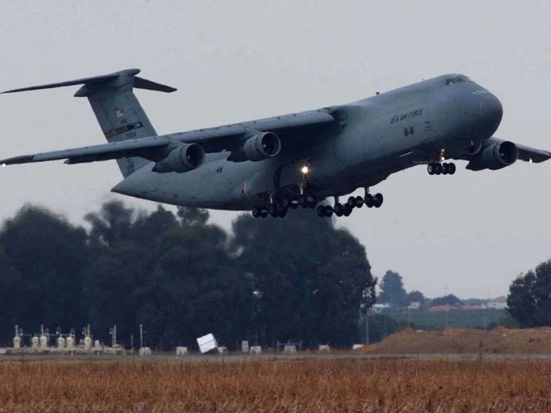
Το γεγονός ότι τα U2, αεροσκάφη αναγνώρισης μεγάλου από πολύ μεγάλο υψόμετρο φιλοξενούνται στη βάση, είναι «το χειρότερα κρυμμένο μυστικό στη Μεσόγειο», σύμφωνα με τον Tζάστιν Κραμπ, διευθύνοντα σύμβουλο της εταιρείας πληροφοριών Sibylline.
Ο Κραμπ, πρώην αξιωματικός του βρετανικού στρατού, δήλωσε πως η διαθεσιμότητα των εικόνων στο Google Maps «έκανε πιο εύκολο απ' ό,τι θα έπρεπε» να χτυπηθεί με ακρίβεια η βάση.
Πρόσθεσε ότι η χρήση του ιστότοπου από τον εχθρό για τη στόχευση δεν ήταν καθόλου καινούργιο φαινόμενο. «Οι αντάρτες που με βομβάρδιζαν στο Ιράκ το 2004 είχαν εικόνες του στρατοπέδου μας από το Google Maps και στόχευαν με βάση τη θέση του ραδιοφωνικού ιστού, προκειμένου να χτυπήσουν περιοχές εντός της περιμέτρου».
Την Κυριακή αποκαλύφθηκε ότι το drone περιείχε ένα ρωσικής κατασκευής σύστημα πλοήγησης Kometa-B, ένα κομμάτι υλικού που εμφανίστηκε για πρώτη φορά σε παρόμοιες συσκευές που κατασχέθηκαν από την ουκρανική αεροπορική άμυνα τον Δεκέμβριο.
Ο σερ Ρίτσαρντ Νάιτον, επικεφαλής των βρετανικών ενόπλων δυνάμεων, επιβεβαίωσε το Σάββατο πως η επίθεση κατά της RAF στην Κύπρο πραγματοποιήθηκε από τον Λίβανο από μια «ομάδα που υποστηρίζει το Ιράν». Πιστεύεται ότι η επίθεση πραγματοποιήθηκε από τη Χεζμπολάχ.
«Η συνεργασία μεταξύ Ιράν και Ρωσίας καθιστά τις δυνάμεις τους πιο ικανές και πιο επικίνδυνες, και γι' αυτό πρέπει να είμαστε έτοιμοι», πρόσθεσε.
Πηγή: iefimerida.gr
Times: Hezbollah Targeted Drones at UK Bases Using Google Maps

The Times reports that Hezbollah appears to have used Google Maps to target drones at the RAF Akrotiri airbase in Cyprus. Satellite images showed two U.S. U2 spy planes parked near the attack site, suggesting Hezbollah had access to information about the location and timing of the aircraft. A military source stated that the accuracy of the attack suggests the use of tools like Google Maps and GPS, rather than a sophisticated intelligence operation. Google has the ability to blur or remove details of sensitive locations for security reasons, which it has done for some Israeli and American airbases, as well as airports like Heathrow. However, the base at Akrotiri remained exposed in satellite images, with the aircraft visible. The British Ministry of Defence declined to comment on efforts to hide parts of the base from Google Maps. Justin Crump, CEO of Sibylline intelligence, pointed out that the presence of the U2 aircraft at the base was an 'open secret,' but the availability of images on Google Maps made accurate targeting easier. Using Google Maps for targeting by hostile forces is not a new phenomenon, as demonstrated by similar incidents in Iraq in 2004. Furthermore, the drone used in the attack contained a Russian-made Kometa-B navigation system, which had also been found in other devices in Ukraine. The attack was attributed by the head of the British armed forces to a group supported by Iran, highlighting growing concerns about regional instability and Iranian involvement.