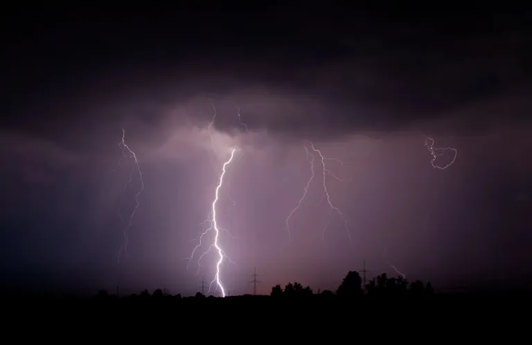
Βαρομετρικό χαμηλό με κέντρο τη Βόρεια Ελλάδα κινείται βορειοανατολικά και αναμένεται να επηρεάσει απόψε και αύριο την περιοχή.
Η πρόγνωση του καιρού από το Τμήμα Μετεωρολογίας
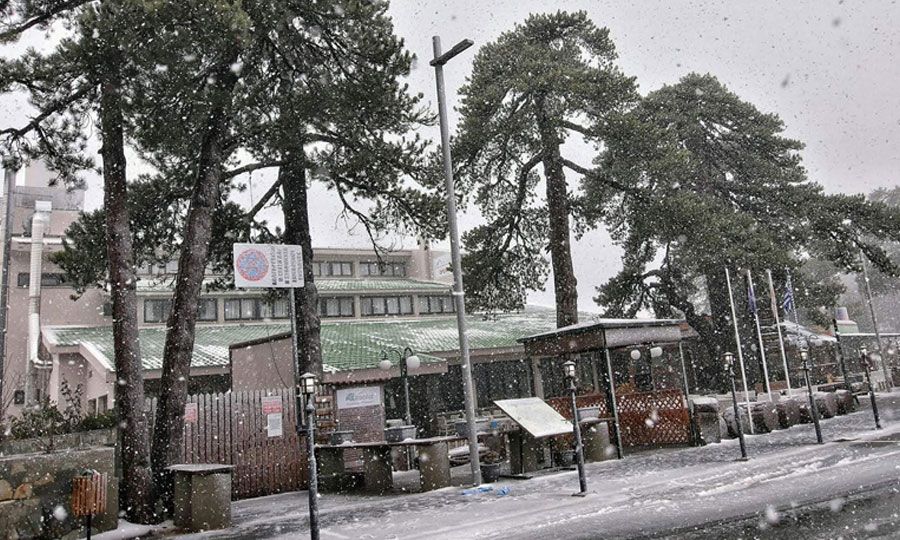
Απόψε, ο καιρός θα είναι μερικώς συννεφιασμένος και αναμένονται μεμονωμένες βροχές και αργότερα και μεμονωμένες καταιγίδες, κυρίως στο δυτικό μισό του νησιού. Στις ψηλότερες κορυφές του Τροόδους ενδέχεται να πέσει χιόνι ή χιονόνερο. Οι άνεμοι θα πνέουν κυρίως νοτιοδυτικοί, αρχικά ισχυροί μέχρι πολύ ισχυροί, 5 με 6 μποφόρ και αργότερα πολύ ισχυροί, 6 μποφόρ. Η θάλασσα θα καταστεί σύντομα ταραγμένη και σταδιακά τοπικά μέχρι κυματώδης. Η θερμοκρασία θα πέσει στους 13 βαθμούς στο εσωτερικό, γύρω στους 16 στα παράλια και στους 6 βαθμούς στα ψηλότερα ορεινά.
Αύριο, ο καιρός θα είναι κυρίως συννεφιασμένος με τοπικές βροχές και μεμονωμένες καταιγίδες, καθώς και χιόνια στα ψηλότερα ορεινά, ενώ από νωρίς το απόγευμα αναμένεται σταδιακή βελτίωση του. Οι άνεμοι θα πνέουν κυρίως νοτιοδυτικοί ως δυτικοί, ισχυροί μέχρι πολύ ισχυροί, 5 με 6 μποφόρ και τοπικά πολύ ισχυροί μέχρι σφοδροί, 6 με 7 μποφόρ. Η θάλασσα θα είναι κυματώδης για να καταστεί σύντομα μέχρι πολύ κυματώδης και τοπικά στα προσήνεμα μέχρι τρικυμιώδης. Η θερμοκρασία θα ανέλθει γύρω στους 18 βαθμούς στο εσωτερικό και τα παράλια και στους 6 βαθμούς στα ψηλότερα ορεινά.
Αύριο βράδυ, ο καιρός θα είναι μερικώς συννεφιασμένος, ενώ αναμένεται να σημειωθούν μεμονωμένες βροχές, κυρίως στο δυτικό μισό του νησιού. Στα ψηλότερα ορεινά ενδέχεται να πέσει χιόνι ή χιονόνερο. Οι άνεμοι θα πνέουν κυρίως νοτιοδυτικοί ως βορειοδυτικοί, μέτριοι μέχρι ισχυροί, 4 με 5 μποφόρ και τοπικά στα παράλια, ισχυροί μέχρι πολύ ισχυροί, 5 με 6 μποφόρ. Η θάλασσα θα είναι κυματώδης μέχρι πολύ κυματώδης.
Την Πέμπτη, την Παρασκευή και το Σάββατο, θα παρατηρούνται κατά διαστήματα τοπικά αυξημένες νεφώσεις. Η θερμοκρασία μέχρι την Παρασκευή δεν αναμένεται να σημειώσει αξιόλογη μεταβολή και θα παραμείνει κοντά στις μέσες κλιματολογικές τιμές, ενώ το Σάββατο αναμένεται να σημειώσει άνοδο.
Storms, Snow and Strong Winds Approaching - Detailed Forecast

A low-pressure system currently over Northern Greece is expected to affect Cyprus tonight and tomorrow, bringing storms, snow, and strong winds. According to the Department of Meteorology, tonight will be partly cloudy with local showers and later isolated thunderstorms, mainly in the western half of the island. Snow or sleet is expected on the higher peaks of Troodos, while winds will be strong to very strong. The sea will become rough and gradually locally wavy. The temperature will drop to 13 degrees Celsius inland, around 16 on the coast, and 6 degrees in the higher mountains. Tomorrow, the weather will be mainly cloudy with local showers and isolated thunderstorms, as well as snow in the mountains. A gradual improvement is expected from early afternoon. Winds will be strong to very strong, locally very strong to gale force. The sea will be wavy, becoming soon very wavy and locally stormy on the windward side. The temperature will rise to around 18 degrees Celsius inland and on the coast, and 6 degrees in the mountains. Tomorrow evening, the weather will be partly cloudy, with isolated showers, mainly in the western half of the island. Snow or sleet is possible in the higher mountains. Winds will be mainly southwesterly to northwesterly, moderate to strong, locally strong to very strong on the coast. The sea will be wavy to very wavy. For Thursday, Friday and Saturday, intermittent local increases in cloud cover are expected. The temperature is not expected to change significantly until Friday and will remain close to the average climatic values, while a rise is expected on Saturday.
You Might Also Like

Νέο κύμα κακοκαιρίας: Έρχονται βροχές, καταιγίδες, χιόνια και πτώση της θερμοκρασίας Δείτε αναλυτικά

Κίτρινη Προειδοποίηση για βροχές, καταιγίδες και χαλάζι – Πότε τίθεται σε ισχύ
Feb 12
Νέα χιονόπτωση στο Τρόοδος - Μαγευτικές εικόνες (ΒΙΝΤΕΟ)
Feb 13

Βροχερό το σκηνικό και το Σάββατο – Έρχεται σκόνη και άνοδος της θερμοκρασίας
Feb 13
Βροχές, καταιγίδες και χαλάζι απόψε - Σε ισχύ κίτρινη προειδοποίηση
Feb 13